Floodplain Management Bylaw Update
Overview
What are we doing?
The Regional District of Central Kootenay (RDCK) and Village of Salmo have partnered to update our Floodplain Management Bylaws.
The RDCK’s current Floodplain Management Bylaw was adopted in 2009 and the Village’s was adopted in 1994. Since adoption, neither bylaw has had a comprehensive review and they both contain outdated regulations and terminology about flood hazard and risk.
The primary goal of this work is to modernize the RDCK and Village of Salmo’s community land use policies, regulations, and mapping related to flood and steep creek hazards.
Why is this important?
Some of the most frequent and damaging natural hazards that the region faces are flood and steep creek hazards (such as debris flows and debris floods). To better understand the risks related to flooding and steep creeks in the region, in 2019 the RDCK conducted a “Regional Geohazard Risk Prioritization Study” under the National Disaster Mitigation Program (NDMP).
This study identified over 400 clear-water flood and steep creek hazards across the RDCK. Further work was then done to complete risk assessments and detailed hazard mapping for high-priority flood and steep creek hazard areas identified in the initial study. This foundational work identified reviewing and updating relevant community land use policies and regulations as an important way to use this new information.
For more information on the NDMP Risk Prioritization work, click the image below and see the “Project Results” under the Hazards – Clear Water and Steep Creek Hazards Section:
The Floodplain Management Bylaw Review Project
The current RDCK Floodplain Management Bylaw applies to all electoral areas and regulates how construction and land development can proceed in areas with known flood hazards. Salmo’s current Floodplain Management Bylaw does the same for the Village. However, neither of these two Bylaws considers the new information gathered since 2019.
The Floodplain Management Bylaw Review will integrate the extensive hazard mapping and risk assessments completed since 2019. This integration will ensure that future development decisions consider the most up-to-date information on flood and steep creek hazards to improve disaster resilience in our communities.
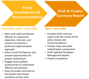
The project began in June 2025 and is anticipated to wrap up in summer of 2026. Below is a summary of the key project activities and timing:

How do I stay informed?
Visit this page regularly for updates, and feel free to contact us directly with any questions or feedback.
Update: Join the Project Team on Tuesday, February 10th, 2026 – 6:30PM (PST) for a live webinar to get the facts and ask your questions about the Floodplain Management Bylaw Review and Risk Tolerance Policy.
Click here to join the Zoom meeting
Meeting ID: 916 2675 8729
Passcode: 293819
OR
Dial by your location
- +1 778 907 2071 Canada
- 833 958 1164 Canada Toll-free
- 855 703 8985 Canada Toll-free
- 833 955 1088 Canada Toll-free
Meeting ID: 916 2675 8729
Passcode: 293819
This project is being delivered with financial support from the Province of British Columbia’s Disaster Resilience and Innovation Funding Program.
Frequently Asked Questions
What is a Floodplain Management Bylaw?
The Floodplain Management Bylaw is a planning tool that helps protect people and property from flooding caused by rivers or lakes, erosion along shorelines, and steep creek hazards such as debris floods and debris flows. The bylaw sets limits on where and how development can happen in areas that are prone to these hazards. The RDCK and member municipalities, such as the Village of Salmo, have their own versions of this bylaw. The RDCK Bylaw applies across all rural Electoral Areas (A–K) and all watercourses in these areas, even if a property isn’t zoned.
Why are the RDCK's and Village of Salmo's Floodplain Management Bylaws being updated?
Both RDCK and Village of Salmo are updating the Floodplain Management Bylaws to reflect current hazard information and standards. RDCK’s bylaw (last updated in 2019) and Salmo’s bylaw (from 1994) do not incorporate more recent hazard maps, updated terminology or requirements. These updates, made possible through Provincial funding, will improve decision-making, reduce community exposure and vulnerability to hazards and align with guideline updates, such as BC’s Provincial Flood Hazard Land Use Management Guideline.
How does the Floodplain Management Bylaw currently impact how I develop on my land?
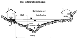
Floodplain Management Bylaws identify areas where developments may be affected by known hazards and must meet specific requirements, such as:
- Minimum ground-floor elevations to protect buildings from flooding (called “Flood Construction Levels”, or FCLs); and,
- Required setback distances from rivers, lakes, and other watercourses.
How does the Floodplain Management Bylaw apply to existing buildings or basement renovations?
Renovations to existing buildings can proceed without meeting Flood Construction Level (FCL) requirements, as long as the work does not add to the existing building footprint. Small additions under 25% of the existing footprint may remain at the original elevation if they meet floodplain setback requirements. Building permit requirements still apply.
Basements, however, are more restricted: new basements below the FCL are not permitted, and existing basements can be renovated only if certain safety measures are in place (e.g., windows and doors are above the FCL, and a strong enough foundation to withstand floodwaters). Floodplain setback rules still apply, even when renovating an existing structure.
What if I can't meet the regulations in the Floodplain Management Bylaw?
If your proposed development is in a flood or steep creek hazard area and does not meet the bylaw requirements, you may apply for a site-specific floodplain exemption. To do this, you’ll need to hire a Qualified Professional (QP)—such as an engineer or geoscientist—to look at your property and prepare a report explaining whether your project can still be considered “safe for the use intended.”
RDCK Planning staff review the application and QP report, assess whether the proposal is consistent with relevant guidelines, policies and regulations, and make a recommendation to the Regional Board. The Regional Board ultimately decides whether to approve or deny the exemption. If an exemption is approved, the RDCK requires a restrictive covenant to be registered on the property title. This document outlines the conditions that make the development safe, helps ensure future property owners will be made aware of the flood or steep‑creek risks, and clarifies responsibility and reduces liability for both the property owner and Regional District.
RDCK Planning staff will only recommend support of applications that demonstrate a valid hardship, meaning there are physical limitations on the property that limit the ability to build outside of the hazard area. Provincial guidelines state that personal preferences (like preferred views or building placement) and financial reasons do not count as hardship.
How will updates to the Floodplain Management change how I develop on my land?
No major changes to RDCK’s floodplain bylaw exemption application process are anticipated. The goal of any updates will be to provide clearer terminology and incorporate more current hazard information. This will help reduce hazard exposure and support a more consistent and transparent development application process across the region.
How can I check if my property is within an area regulated by a Floodplain Management Bylaw?
If you have a watercourse on your property or are located along a lake, river or creek, the bylaw may impact your development. The RDCK Public WebMap provides information on mapped hazard zones and outlines areas subject to regulations under the respective Floodplain Management Bylaws. See the “Community Planning Services Layer” in the Webmap (relevant layers shown below):
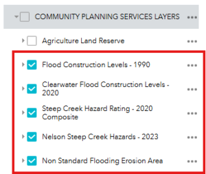
If, after referencing the RDCK Public Webmap and the relevant Floodplain Management Bylaw, you are still unclear on whether your property is in a floodplain, contact the RDCK Planning Department at plandept@rdck.bc.ca or (250) 352-1536.
Will the updated Floodplain Management Bylaws change whether my property is shown in a flood or steep creek hazard area?
Yes, it’s possible. RDCK and Salmo are updating their bylaws to incorporate new flood, erosion, and steep creek hazard mapping completed since 2019. These updated maps provide more accurate information about where flood and steep creek hazards exist.
Given the current bylaws use older or incomplete maps, some properties may be newly identified within a hazard area in the updated maps while others may no longer be included.
Updated mapping will ensure development requirements are based on the most current understanding of hazards, increasing clarity for property owners when making decisions on where and how to develop and when applying for permits. Updated mapping is a result of new data collection (e.g., lidar, surveys) and advances in hydraulic modelling and climate change science.
Links
RDCK Floodplain Management Bylaw No. 2080, 2009
The current RDCK Floodplain Management Bylaw
Village of Salmo Floodplain Management Bylaw No. 382, 1994
The current Village of Salmo Floodplain Management Bylaw
Regional Geohazard Risk Prioritization Study (NDMP)
See the "Hazards – Clear Water and Steep Creek Hazards" section of the Community Planning Projects page for the region wide assessments
What are we doing?
The Regional District of Central Kootenay (RDCK) and Village of Salmo have partnered to update our Floodplain Management Bylaws.
The RDCK’s current Floodplain Management Bylaw was adopted in 2009 and the Village’s was adopted in 1994. Since adoption, neither bylaw has had a comprehensive review and they both contain outdated regulations and terminology about flood hazard and risk.
The primary goal of this work is to modernize the RDCK and Village of Salmo’s community land use policies, regulations, and mapping related to flood and steep creek hazards.
Why is this important?
Some of the most frequent and damaging natural hazards that the region faces are flood and steep creek hazards (such as debris flows and debris floods). To better understand the risks related to flooding and steep creeks in the region, in 2019 the RDCK conducted a “Regional Geohazard Risk Prioritization Study” under the National Disaster Mitigation Program (NDMP).
This study identified over 400 clear-water flood and steep creek hazards across the RDCK. Further work was then done to complete risk assessments and detailed hazard mapping for high-priority flood and steep creek hazard areas identified in the initial study. This foundational work identified reviewing and updating relevant community land use policies and regulations as an important way to use this new information.
For more information on the NDMP Risk Prioritization work, click the image below and see the “Project Results” under the Hazards – Clear Water and Steep Creek Hazards Section:
The Floodplain Management Bylaw Review Project
The current RDCK Floodplain Management Bylaw applies to all electoral areas and regulates how construction and land development can proceed in areas with known flood hazards. Salmo’s current Floodplain Management Bylaw does the same for the Village. However, neither of these two Bylaws considers the new information gathered since 2019.
The Floodplain Management Bylaw Review will integrate the extensive hazard mapping and risk assessments completed since 2019. This integration will ensure that future development decisions consider the most up-to-date information on flood and steep creek hazards to improve disaster resilience in our communities.
The project began in June 2025 and is anticipated to wrap up in summer of 2026. Below is a summary of the key project activities and timing:
How do I stay informed?
Visit this page regularly for updates, and feel free to contact us directly with any questions or feedback.
Update: Join the Project Team on Tuesday, February 10th, 2026 – 6:30PM (PST) for a live webinar to get the facts and ask your questions about the Floodplain Management Bylaw Review and Risk Tolerance Policy.
Click here to join the Zoom meeting
Meeting ID: 916 2675 8729
Passcode: 293819
OR
Dial by your location
- +1 778 907 2071 Canada
- 833 958 1164 Canada Toll-free
- 855 703 8985 Canada Toll-free
- 833 955 1088 Canada Toll-free
Meeting ID: 916 2675 8729
Passcode: 293819
This project is being delivered with financial support from the Province of British Columbia’s Disaster Resilience and Innovation Funding Program.
Frequently Asked Questions
What is a Floodplain Management Bylaw?
The Floodplain Management Bylaw is a planning tool that helps protect people and property from flooding caused by rivers or lakes, erosion along shorelines, and steep creek hazards such as debris floods and debris flows. The bylaw sets limits on where and how development can happen in areas that are prone to these hazards. The RDCK and member municipalities, such as the Village of Salmo, have their own versions of this bylaw. The RDCK Bylaw applies across all rural Electoral Areas (A–K) and all watercourses in these areas, even if a property isn’t zoned.
Why are the RDCK's and Village of Salmo's Floodplain Management Bylaws being updated?
Both RDCK and Village of Salmo are updating the Floodplain Management Bylaws to reflect current hazard information and standards. RDCK’s bylaw (last updated in 2019) and Salmo’s bylaw (from 1994) do not incorporate more recent hazard maps, updated terminology or requirements. These updates, made possible through Provincial funding, will improve decision-making, reduce community exposure and vulnerability to hazards and align with guideline updates, such as BC’s Provincial Flood Hazard Land Use Management Guideline.
How does the Floodplain Management Bylaw currently impact how I develop on my land?
Floodplain Management Bylaws identify areas where developments may be affected by known hazards and must meet specific requirements, such as:
- Minimum ground-floor elevations to protect buildings from flooding (called “Flood Construction Levels”, or FCLs); and,
- Required setback distances from rivers, lakes, and other watercourses.
How does the Floodplain Management Bylaw apply to existing buildings or basement renovations?
Renovations to existing buildings can proceed without meeting Flood Construction Level (FCL) requirements, as long as the work does not add to the existing building footprint. Small additions under 25% of the existing footprint may remain at the original elevation if they meet floodplain setback requirements. Building permit requirements still apply.
Basements, however, are more restricted: new basements below the FCL are not permitted, and existing basements can be renovated only if certain safety measures are in place (e.g., windows and doors are above the FCL, and a strong enough foundation to withstand floodwaters). Floodplain setback rules still apply, even when renovating an existing structure.
What if I can't meet the regulations in the Floodplain Management Bylaw?
If your proposed development is in a flood or steep creek hazard area and does not meet the bylaw requirements, you may apply for a site-specific floodplain exemption. To do this, you’ll need to hire a Qualified Professional (QP)—such as an engineer or geoscientist—to look at your property and prepare a report explaining whether your project can still be considered “safe for the use intended.”
RDCK Planning staff review the application and QP report, assess whether the proposal is consistent with relevant guidelines, policies and regulations, and make a recommendation to the Regional Board. The Regional Board ultimately decides whether to approve or deny the exemption. If an exemption is approved, the RDCK requires a restrictive covenant to be registered on the property title. This document outlines the conditions that make the development safe, helps ensure future property owners will be made aware of the flood or steep‑creek risks, and clarifies responsibility and reduces liability for both the property owner and Regional District.
RDCK Planning staff will only recommend support of applications that demonstrate a valid hardship, meaning there are physical limitations on the property that limit the ability to build outside of the hazard area. Provincial guidelines state that personal preferences (like preferred views or building placement) and financial reasons do not count as hardship.
How will updates to the Floodplain Management change how I develop on my land?
No major changes to RDCK’s floodplain bylaw exemption application process are anticipated. The goal of any updates will be to provide clearer terminology and incorporate more current hazard information. This will help reduce hazard exposure and support a more consistent and transparent development application process across the region.
How can I check if my property is within an area regulated by a Floodplain Management Bylaw?
If you have a watercourse on your property or are located along a lake, river or creek, the bylaw may impact your development. The RDCK Public WebMap provides information on mapped hazard zones and outlines areas subject to regulations under the respective Floodplain Management Bylaws. See the “Community Planning Services Layer” in the Webmap (relevant layers shown below):
If, after referencing the RDCK Public Webmap and the relevant Floodplain Management Bylaw, you are still unclear on whether your property is in a floodplain, contact the RDCK Planning Department at plandept@rdck.bc.ca or (250) 352-1536.
Will the updated Floodplain Management Bylaws change whether my property is shown in a flood or steep creek hazard area?
Yes, it’s possible. RDCK and Salmo are updating their bylaws to incorporate new flood, erosion, and steep creek hazard mapping completed since 2019. These updated maps provide more accurate information about where flood and steep creek hazards exist.
Given the current bylaws use older or incomplete maps, some properties may be newly identified within a hazard area in the updated maps while others may no longer be included.
Updated mapping will ensure development requirements are based on the most current understanding of hazards, increasing clarity for property owners when making decisions on where and how to develop and when applying for permits. Updated mapping is a result of new data collection (e.g., lidar, surveys) and advances in hydraulic modelling and climate change science.
Who's listening
Key Dates
The project team introduced this project to the RDCK Board of Directors on September 18, 2025. An overview of the project goal, structure and timeline was presented at that meeting. A presentation recording can be found in the “Meeting Recordings and Presentations” section of this project page.
A live webinar to get the facts and ask your questions on the Floodplain Management Bylaw Review and the Risk Tolerance Policy Projects.
Click Here to Join the Webinar
Meeting ID: 916 2675 8729
Passcode: 293819
Exact date to be determined. Check back here in the spring for an exact date and link.
Completion of the Review and project summary report.