
Goat River Watershed Water Sustainability Planning
Overview
Water Sustainability in the Goat River Watershed
The Regional District of Central Kootenay (RDCK), in collaboration with yaqan nuʔkiy, is doing water sustainability planning to respond to growing concerns about water availability in the Goat River Watershed (includes the communities of Canyon, Erickson, Kitchener, Lister, Town of Creston, West Creston, Wynndel, and yaqan nuʔkiy). This effort aims to protect the health and resilience of the local watersheds that support communities, ecosystems, and economies.
This page will keep you informed about the project’s progress and provide opportunities to participate through surveys, conversations, and events. Your input will help shape a locally grounded approach to watershed sustainability that reflects the values and needs of the region. Below are some simple ways to stay informed and share your perspective:
Take the Water Sustainability Planning Survey
Join our mailing list
Read the latest newsletter (June 2026)
Explore the 3D Goat River Watershed Map
Latest News
On the Land Gathering and Drop in on July 24, 2026 *INDOOR EVENT ONLY*
‼️On the Land Gathering Moved to Creston & District Community Complex due to Smoke
Due to today’s Air Quality Health Index warning (currently in the Unhealthy range from wildfire smoke), we are moving the outdoor portion of today’s events indoors. All activities will now take place at The Creston & District Community Complex. We appreciate your understanding as we prioritize attendee health and safety. If you have questions, please reach out to Camille at 250-352-1543
Join us in the morning for a facilitated discussion and activity where you can share your perspective, values and vision for the Goat River Watershed.
The afternoon will be a casual drop-in session where you can speak with staff and pick up a copy of the What We Heard Report and Water Sustainability Survey.
Gathering and Drop In
When: July 24, 2026 – 9:30 – 11:30 am (Kootenay Room) and 1 – 3 pm (Lobby)
Where: Creston and District Community Complex
Input gathered on the day will contribute to the conversations underway between the RDCK, yaqan nuʔkiy, and the Province.
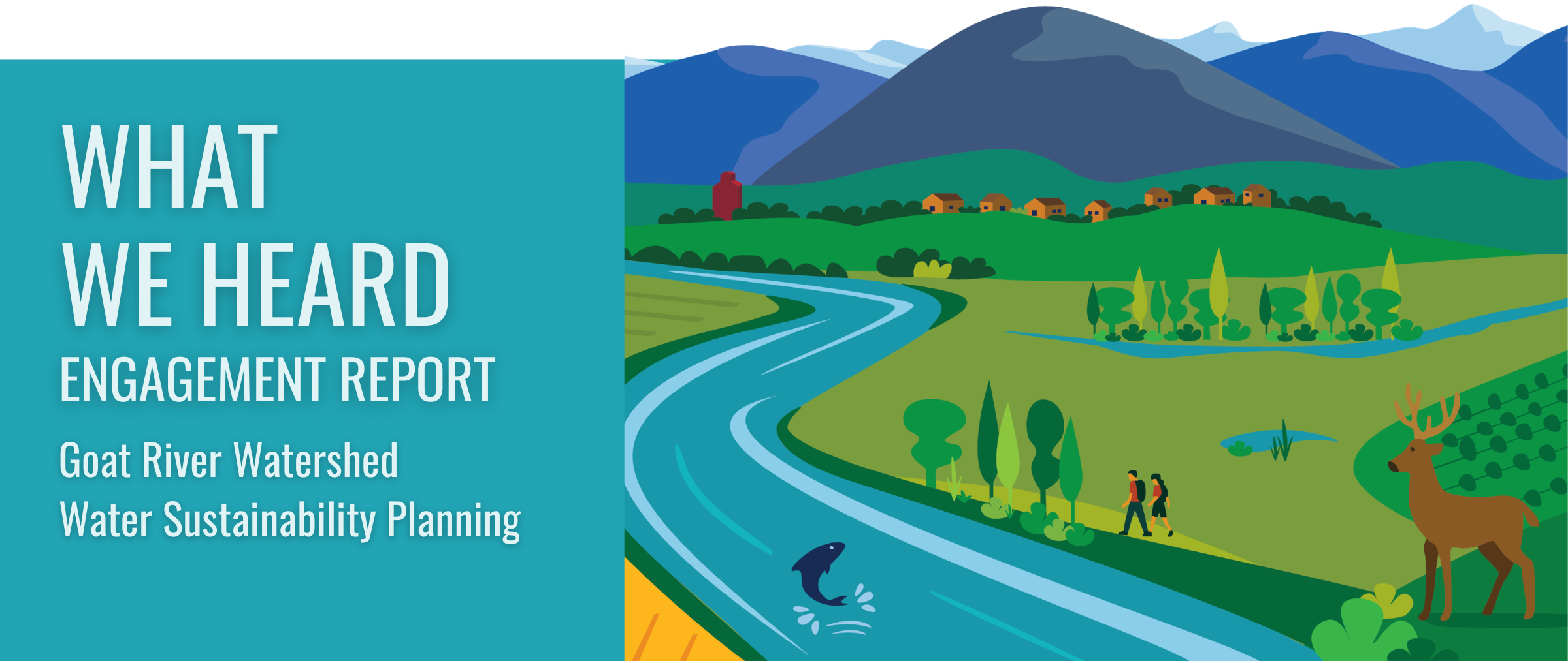
The What We Heard Engagement Report is now available
This report brings together what was heard through engagement carried out in 2025 and into early 2026 regarding the Goat River Watershed Water Sustainability Planning. Input was gathered through a Water Values Survey (220 responses), six open houses in Canyon, Erickson, Kitchener, Town of Creston, West Creston, and Wynndel (137 participants), Kitchen Table Conversations, the engage page – engage.rdck.ca/projects/goatwatershed, and a dedicated producer engagement initiative including on-farm visits with 15 producers. Together, these engagement streams reached a broad cross-section of residents, agricultural producers, and community members.
Read the full report to see what was shared. Thank you to all who shared your stories and perspectives with us.
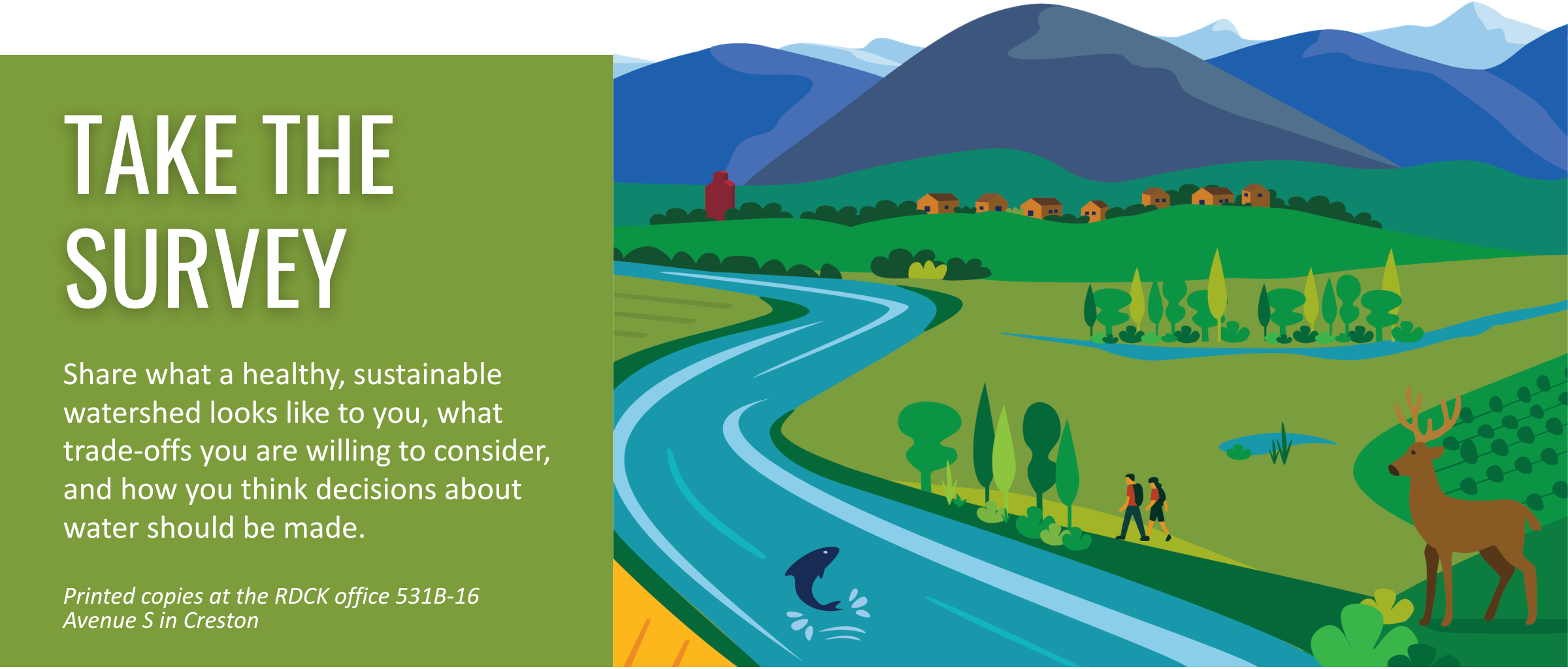
Take the Water Sustainability Planning Survey
Thank you to everyone who completed the Water Values Survey, our first survey on water in the Goat River Watershed. Over 220 people shared their experiences, concerns, and ideas. You told us clearly that water levels are declining, that you care deeply about this watershed, and that you want action, not just conversation.
This second survey goes further. We want to understand what a healthy, sustainable watershed looks like to you, what trade-offs you are willing to consider, and how you think decisions about water should be made. Your input will contribute to the conversations currently under way between the RDCK, yaqan nuʔkiy. and the RDCK (also known as the Collective Conversations Working Group).
The survey takes approximately 10 to 12 minutes to complete. All responses are anonymous.
Collective Conversation Working Group (updated June 2026)
In late May, RDCK staff met with the Province (Ministries of Water Land and Resource Stewardship, Forests and Agriculture) and yaqan nuʔkiy for the first meeting of the Collective Conversations Working Group. This group will meet 5 more times between July and October to build shared understanding of conditions, roles and responsibilities, and priorities across the watershed. The overall aim of this working group is to work together on scoping a water management solution to address water related challenges experienced in the yaqan nuʔkiy ?amak?is Creston Valley Goat River Watershed.
Through a series of collective and sequenced conversations, the Collective Conversations Working Group will identify and consider a path forward to address water issues being faced in the watershed.
The Province is wanting to support coordinated, collaborative, and informed planning and decision-making processes that build on the work already undertaken by RDCK and yaqan nuʔkiy The Collective Conversations working group will build a shared understanding of:
- values associated with the watershed; current state of the watershed;
- key issues, challenges, and pressures influencing the watershed;
- knowledge and data gaps that may warrant further consideration;
- respective interests and areas of alignment;
- a long-term vision for the watershed;
- expectations and authority for watershed governance and water management decision-making;
- and available next steps for long-term water management approaches for our respective decision-makers’ consideration.
RDCK staff leading this process aren’t decision-makers; the RDCK Board holds that authority. The Collective Conversations Working Group may bring recommendations to the RDCK Board. To stay closely engaged, the Creston Valley Service Committee (CVSC) directors and RDCK staff meet monthly alongside the Collective Conversations Working Group. RDCK staff will continue meeting regularly with the Province, yaqan nuʔkiy, and the CVSC Directors through to October.
Creston Valley Services Committee (CVSC)
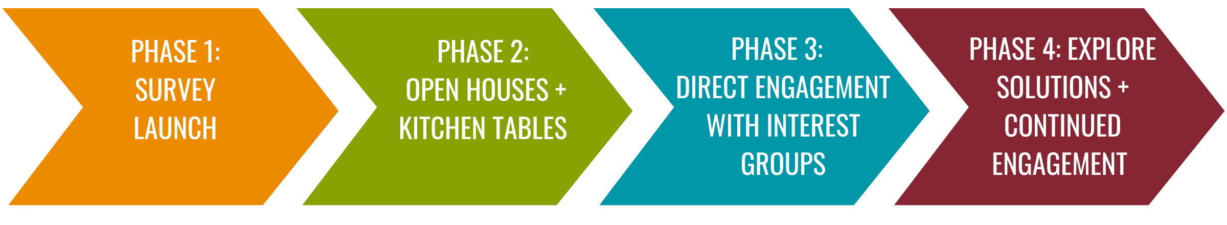
Engagement Approach
This work reflects a shared commitment to respectful relationships, deep listening, and collaborative solutions that consider both Indigenous and local knowledge systems.
We’re inviting the public, interest groups, and local leaders to take part in a series of conversations, campaigns, and storytelling activities. Engagement will unfold over four phases:
How To Get Involved
 Connectors host conversations with family, friends, or neighbours about water. These kitchen-table discussions are a chance to explore local issues, hear perspectives, and share ideas for action. Explore the Kitchen Table Discussion Guide (under the Documents tab)

Storytellers share their personal connection to water, whether through memories, observations of change, or hopes for the future. Stories may appear in reports, on social media, or on the RDCK website. Reach out to Camille to set up an interview or share your story over email to cleblanc@rdck.bc.ca

Contributors share their voice through the Water Sustainability Planning Survey, forums, or conversations. Your input helps build understanding of water sustainability in the Goat River Watershed. You’re also encouraged to join our mailing list for updates, resources, and future opportunities.
Learners are eager to deepen their understanding of what it takes to build a sustainable water future in the Goat River Watershed. Join our mailing list.
Background
All beings in the region are increasingly affected by the impacts and pressures on water systems. In recent years, the area has experienced diminishing water supplies, dry wells, crop losses from heat, flooding, and shifting pest patterns due to milder winters.
In May 2024, yaqan nuʔkiy and the RDCK sent a letter to the Ministry of Water, Land and Resource Stewardship (WLRS) requesting support for this work and expressing interest in creating a Water Sustainability Plan. WLRS responded with support, recognizing the need for a new, collaborative approach to watershed stewardship in the valley.
Funders
- Watershed Security Fund
- Union of BC Municipalities: Community to Community
- Investment Agriculture Foundation BC
Thank you for your support
Frequently Asked Questions
What is the reason why the RDCK considers the Goat River a sensitive ecosystem?
The Goat River Watershed is considered a sensitive ecosystem because it provides critical ecological and hydrological functions that directly influence community water supply, fish habitat, and agricultural productivity. The watershed supports surface and groundwater systems that are hydrologically connected to the Canyon (0489) and East Creston/Lister (0488) aquifer, both of which are provincially recognized as at-risk drinking water sources and agricultural supply areas. See a breakdown of the research we are referencing here (page 3)
Has the Creston Valley Alternative Water Supply Feasibility Study considered water quality as well as quantity when assessing the Kootenay River as a potential irrigation source, and has any water quality testing been done?
The Creston Valley Alternative Water Supply Feasibility Study https://engage.rdck.ca/cvstudy examined the technical potential of supplementing irrigation water from the Kootenay River, recognizing that existing allocations from Goat River and Arrow Creek are nearing capacity during low-flow periods.
These findings underscore that further site-specific testing would be required before making a final selection of the Kootenay River as an irrigation source. The study reference can be found here: The Creston Centralized Water Feasibility Study (2025, DRAFT) details these assessments, including flow modelling and source water analysis. [RDCK Draft Report, Feb 2025]
Links
Documents
What We Heard Report
Kitchen Table Conversation Guide and Worksheets
GRW Water Sustainability Planning One-Page Brochure
Producer Lunch and Learn Watershed Background Information
Goat River Watershed Study Area Map PDF
CVSC Slides - July
Newsletters
Survey
Water Sustainability Planning Survey
Thank you to everyone who completed the Water Values Survey, our first survey on water in the Goat River Watershed. Over 220 people shared their experiences, concerns, and ideas. You told us clearly that water levels are declining, that you care deeply about this watershed, and that you want action, not just conversation. This second survey goes further. We want to understand what a healthy, sustainable watershed looks like to you, what trade-offs you are willing to consider, and how you think decisions about water should be made. Your input will contribute to the conversations currently under way between the RDCK, yaqan nuʔkiy. and the RDCK (also known as the Collective Conversations Working Group). The survey takes approximately 10 to 12 minutes to complete. All responses are anonymous. Submit by August 1st 2026
Take the SurveyWater Sustainability in the Goat River Watershed
The Regional District of Central Kootenay (RDCK), in collaboration with yaqan nuʔkiy, is doing water sustainability planning to respond to growing concerns about water availability in the Goat River Watershed (includes the communities of Canyon, Erickson, Kitchener, Lister, Town of Creston, West Creston, Wynndel, and yaqan nuʔkiy). This effort aims to protect the health and resilience of the local watersheds that support communities, ecosystems, and economies.
This page will keep you informed about the project’s progress and provide opportunities to participate through surveys, conversations, and events. Your input will help shape a locally grounded approach to watershed sustainability that reflects the values and needs of the region. Below are some simple ways to stay informed and share your perspective:
Take the Water Sustainability Planning Survey
Join our mailing list
Read the latest newsletter (June 2026)
Explore the 3D Goat River Watershed Map
Latest News
On the Land Gathering and Drop in on July 24, 2026 *INDOOR EVENT ONLY*
‼️On the Land Gathering Moved to Creston & District Community Complex due to Smoke
Due to today’s Air Quality Health Index warning (currently in the Unhealthy range from wildfire smoke), we are moving the outdoor portion of today’s events indoors. All activities will now take place at The Creston & District Community Complex. We appreciate your understanding as we prioritize attendee health and safety. If you have questions, please reach out to Camille at 250-352-1543
Join us in the morning for a facilitated discussion and activity where you can share your perspective, values and vision for the Goat River Watershed.
The afternoon will be a casual drop-in session where you can speak with staff and pick up a copy of the What We Heard Report and Water Sustainability Survey.
Gathering and Drop In
When: July 24, 2026 – 9:30 – 11:30 am (Kootenay Room) and 1 – 3 pm (Lobby)
Where: Creston and District Community Complex
Input gathered on the day will contribute to the conversations underway between the RDCK, yaqan nuʔkiy, and the Province.
The What We Heard Engagement Report is now available
This report brings together what was heard through engagement carried out in 2025 and into early 2026 regarding the Goat River Watershed Water Sustainability Planning. Input was gathered through a Water Values Survey (220 responses), six open houses in Canyon, Erickson, Kitchener, Town of Creston, West Creston, and Wynndel (137 participants), Kitchen Table Conversations, the engage page – engage.rdck.ca/projects/goatwatershed, and a dedicated producer engagement initiative including on-farm visits with 15 producers. Together, these engagement streams reached a broad cross-section of residents, agricultural producers, and community members.
Read the full report to see what was shared. Thank you to all who shared your stories and perspectives with us.
Take the Water Sustainability Planning Survey
Thank you to everyone who completed the Water Values Survey, our first survey on water in the Goat River Watershed. Over 220 people shared their experiences, concerns, and ideas. You told us clearly that water levels are declining, that you care deeply about this watershed, and that you want action, not just conversation.
This second survey goes further. We want to understand what a healthy, sustainable watershed looks like to you, what trade-offs you are willing to consider, and how you think decisions about water should be made. Your input will contribute to the conversations currently under way between the RDCK, yaqan nuʔkiy. and the RDCK (also known as the Collective Conversations Working Group).
The survey takes approximately 10 to 12 minutes to complete. All responses are anonymous.
Collective Conversation Working Group (updated June 2026)
In late May, RDCK staff met with the Province (Ministries of Water Land and Resource Stewardship, Forests and Agriculture) and yaqan nuʔkiy for the first meeting of the Collective Conversations Working Group. This group will meet 5 more times between July and October to build shared understanding of conditions, roles and responsibilities, and priorities across the watershed. The overall aim of this working group is to work together on scoping a water management solution to address water related challenges experienced in the yaqan nuʔkiy ?amak?is Creston Valley Goat River Watershed.
Through a series of collective and sequenced conversations, the Collective Conversations Working Group will identify and consider a path forward to address water issues being faced in the watershed.
The Province is wanting to support coordinated, collaborative, and informed planning and decision-making processes that build on the work already undertaken by RDCK and yaqan nuʔkiy The Collective Conversations working group will build a shared understanding of:
- values associated with the watershed; current state of the watershed;
- key issues, challenges, and pressures influencing the watershed;
- knowledge and data gaps that may warrant further consideration;
- respective interests and areas of alignment;
- a long-term vision for the watershed;
- expectations and authority for watershed governance and water management decision-making;
- and available next steps for long-term water management approaches for our respective decision-makers’ consideration.
RDCK staff leading this process aren’t decision-makers; the RDCK Board holds that authority. The Collective Conversations Working Group may bring recommendations to the RDCK Board. To stay closely engaged, the Creston Valley Service Committee (CVSC) directors and RDCK staff meet monthly alongside the Collective Conversations Working Group. RDCK staff will continue meeting regularly with the Province, yaqan nuʔkiy, and the CVSC Directors through to October.
Creston Valley Services Committee (CVSC)
Engagement Approach
This work reflects a shared commitment to respectful relationships, deep listening, and collaborative solutions that consider both Indigenous and local knowledge systems.
We’re inviting the public, interest groups, and local leaders to take part in a series of conversations, campaigns, and storytelling activities. Engagement will unfold over four phases:
How To Get Involved
Connectors host conversations with family, friends, or neighbours about water. These kitchen-table discussions are a chance to explore local issues, hear perspectives, and share ideas for action. Explore the Kitchen Table Discussion Guide (under the Documents tab)
Storytellers share their personal connection to water, whether through memories, observations of change, or hopes for the future. Stories may appear in reports, on social media, or on the RDCK website. Reach out to Camille to set up an interview or share your story over email to cleblanc@rdck.bc.ca
Contributors share their voice through the Water Sustainability Planning Survey, forums, or conversations. Your input helps build understanding of water sustainability in the Goat River Watershed. You’re also encouraged to join our mailing list for updates, resources, and future opportunities.
Learners are eager to deepen their understanding of what it takes to build a sustainable water future in the Goat River Watershed. Join our mailing list.
Background
All beings in the region are increasingly affected by the impacts and pressures on water systems. In recent years, the area has experienced diminishing water supplies, dry wells, crop losses from heat, flooding, and shifting pest patterns due to milder winters.
In May 2024, yaqan nuʔkiy and the RDCK sent a letter to the Ministry of Water, Land and Resource Stewardship (WLRS) requesting support for this work and expressing interest in creating a Water Sustainability Plan. WLRS responded with support, recognizing the need for a new, collaborative approach to watershed stewardship in the valley.
Funders
- Watershed Security Fund
- Union of BC Municipalities: Community to Community
- Investment Agriculture Foundation BC
Thank you for your support
Frequently Asked Questions
What is the reason why the RDCK considers the Goat River a sensitive ecosystem?
The Goat River Watershed is considered a sensitive ecosystem because it provides critical ecological and hydrological functions that directly influence community water supply, fish habitat, and agricultural productivity. The watershed supports surface and groundwater systems that are hydrologically connected to the Canyon (0489) and East Creston/Lister (0488) aquifer, both of which are provincially recognized as at-risk drinking water sources and agricultural supply areas. See a breakdown of the research we are referencing here (page 3)
Has the Creston Valley Alternative Water Supply Feasibility Study considered water quality as well as quantity when assessing the Kootenay River as a potential irrigation source, and has any water quality testing been done?
The Creston Valley Alternative Water Supply Feasibility Study https://engage.rdck.ca/cvstudy examined the technical potential of supplementing irrigation water from the Kootenay River, recognizing that existing allocations from Goat River and Arrow Creek are nearing capacity during low-flow periods.
These findings underscore that further site-specific testing would be required before making a final selection of the Kootenay River as an irrigation source. The study reference can be found here: The Creston Centralized Water Feasibility Study (2025, DRAFT) details these assessments, including flow modelling and source water analysis. [RDCK Draft Report, Feb 2025]
Discussion
No discussions yet. Be the first to start one!
No discussions yet. Be the first to start one!
Who's listening
Key Dates
We began by opening a space for reflection and dialogue. The Water Values survey invites you to share how you feel about the state of water and your personal observations. The goal is to listen and learn from a wide range of experiences and voices.
Each open house began with a drop-in session where residents explored information displays highlighting local water challenges, project goals, and watershed data. A short presentation followed, summarizing the information and providing context for the project. Participants then took part in facilitated discussions, where they asked questions, shared local knowledge, and provided input on water priorities and concerns.
This work was carried out in partnership with yaqan nuʔkiy and was guided by community input throughout the process. Updates, educational tools, and future engagement opportunities will continue to be shared here as the project moves forward.
Open houses were hosted between October 22 – November 12, 2025 in Wynndel, West Creston, Town of Creston, Kitchener, Canyon and Erickson.
Producers were invited to a Lunch and Learn on January 8 at Jimmy’s Pub to talk about water, agriculture, and planning for water sustainability in the Goat River Watershed. Participants heard from local experts, shared their experiences, and helped shape the future of the Goat River Watershed.
All were invited to join the RDCK at the Creston Valley Visitor Centre for the unveiling of the 3D model of the Goat River Watershed. Visitors explored the landscape through the 3D model, viewed place names in both Ktunaxa and English, and had the opportunity to drop in, take a closer look, and chat about the land and water that connect the community.
Producer engagement was led by Gen Bergeron, who focused on building relationships and learning directly from farmers and land stewards across the watershed. Through one-on-one conversations, farm visits, and outreach at local farm stands, Gen connected with producers to better understand how water availability, timing, and infrastructure challenges are affecting their operations. This work highlighted the importance of reliable systems, aging infrastructure, and seasonal pressures, while also recognizing the many ways producers are already adapting. The insights gathered are helping to ground the project in local knowledge and ensure that future discussions reflect the realities of agricultural water use in the region.
If you are a farmer who missed the winter and spring conversations and would like to connect or share your perspectives, please reach out to Camille to find out how to get involved.
This report brings together what was heard through engagement carried out in 2025 and into early 2026 regarding the Goat River Watershed Water Sustainability Planning. Input was gathered through a Water Values Survey (220 responses), six open houses in Canyon, Erickson, Kitchener, Town of Creston, West Creston, and Wynndel (137 participants), Kitchen Table Conversations, the engage page – engage.rdck.ca/projects/goatwatershed, and a dedicated producer engagement initiative including on-farm visits with 15 producers. Together, these engagement streams reached a broad cross-section of residents, agricultural producers, and community members.
Read the full report to see what was shared. Thank you to all who shared your stories and perspectives with us.
We want to understand what a healthy, sustainable watershed looks like to you, what trade-offs you are willing to consider, and how you think decisions about water should be made. Your input will contribute to the conversations currently under way between the RDCK, yaqan nuʔkiy. and the RDCK (also known as the Collective Conversations Working Group).
The survey takes approximately 10 to 12 minutes to complete. All responses are anonymous.
RDCK staff and a guest from Ministry of Agriculture and Food on Wednesday, July 8 from 11 am to 1 pm at Kootenay Farmers Supply (754 35th Ave South, Creston) provided an update on the Goat River Watershed Water Sustainability Planning project. Residents provided input on water management in their water systems and received reports, surveys, and updates on the project.

