
Area D Community Planning
Overview
Overview
The Area D Community Planning project follows up on work completed in 2021 to host land use planning discussions for communities in Area D. The goal of this project is to create new opportunities for community land use discussions between the RDCK and Area D Community members – to learn about different planning tools and to listen to communities about their needs regarding land use. With community direction, the RDCK planning department can work towards updating the Area D Comprehensive Land Use Bylaw focusing on updating and expanding planning tools such as zoning to additional communities that want them.
Why are we doing this?
The process and adoption of Area D’s current land use bylaw in 2009 and zoning in Ainsworth in 2016 were the last time communities have had a say about land use planning for their area. Area D has changed over the last decade. Communities are experiencing new development pressures, housing challenges, environmental concerns, water resources issues, and changing expectations about how land should be used. With communities expressing increasing pressures, this is a good time to ask if land use planning is a tool communities would like or not.
Process
It is essential that this project is a community-driven process. To facilitate this, the project has been split into three phases. Each phase will have its own community engagement with summarized reporting back. The end of each phase will have a decision point directing whether to continue on to the next phase.
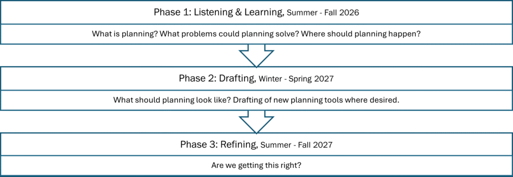
Phase 1 is intended to check back in with Area D communities and build off work completed in 2021. As time has passed and community priorities and concerns may have shifted, this phase will:
- Refresh planning knowledge
- Get communities engaged
- Understand community needs
- Determine communities (if any) that have a desire for zoning
2021 Findings
In 2021 the RDCK hosted 6 community open houses and followed up with a survey. The purpose of the survey was to:
- Hear from Area D community members about what is important to their community, the issues they may be experiencing, and the issues that they want to avoid in the future
- Understand if there is interest from different communities to explore land use planning as a tool to address community concerns or not.
Click the icon below to see what community members said in 2021.
Frequently Asked Questions
What is Community Planning?
Community Planning is a participatory process in which residents, property owners and other stakeholders develop a vision and objectives for their respective communities.
What does planning accomplish?
Planning addresses the use of land, resources, facilities and services in ways that secure the physical, economic and social efficiency, health and well-being of urban and rural communities.
Planning can be a way for the community to work with their local government to address local land use concerns including directing where new development should go, identifying where lands should not be developed, protecting rural character, water sustainability, private land logging, cannabis, short term rentals etc.
Does it increase my property taxes if there is planning?
No. Planning is a service provided whether you have a ‘plan’ or ‘have no plan’ and does not result in increased property taxation. All Electoral Areas currently pay into the planning service as some land use bylaws such as the Floodplain Management Bylaw and Subdivision Bylaw are applicable everywhere in the RDCK.
What is an Official Community Plan?
A plan describing the long term vision of a community through objectives and policies.
An Official Community Plan (OCP) is a statement of the objectives and policies of the local government respecting land use in the area covered by the OCP.
OCPs include policies on:
- Housing
- Commercial, industrial, institutional, agricultural, recreational & public utility land uses
- Natural environment
- Sand & gravel resources
- Hazards
- Infrastructure such as road, sewer & water systems
- Public facilities including schools & parks
- Greenhouse gas emissions
Parts of an OCP can be specific to each individual community or can be directed to an overall framework for the wider plan area under review.
The making of an OCP is a collaborative process with extensive consultation with the public, local business owners, community associations, non profits, First Nations, school districts, and other government agencies.
The purpose of an OCP is to guide future land use decisions by local and provincial governments for the next 10 to 20 years. An OCP can be adopted on its own or with a set of regulatory bylaws to implement the OCP’s policies. The strength of an OCP is that all bylaws adopted after the OCP must be aligned with its polices. OCPs themselves only regulate land use with Development Permit Areas.
What is a Zoning Bylaw?
A regulatory bylaw to govern growth and land use activities.
Zoning implements the land use planning visions expressed an Official Community Plan. Zoning bylaws regulate how land, buildings and other structures may be used. Zoning bylaws may divide the whole or part of an area into zones, name each zone and establish the boundaries of those zones.
The following may be regulated within a zone:
- Use and density of land, buildings and other structures
- Siting, size and dimensions of buildings and other structures and permitted uses
- Location of uses on the land and within buildings and other structures
- Shape, dimensions and area of all parcels of land created by subdivision (this can include establishing minimum and maximum parcel sizes)
Zoning implements the land use planning visions expressed in an OCP, as a Zoning Bylaw must be consistent with the policy framework adopted in an OCP.
What are some other planning tools?
If there is an Official Community Plan:
Development Use Permits – a permit for locations that need special treatment for certain purposes.
Development permit areas identify locations that need special treatment for certain purposes such as:
- Protection of the natural environment
- Protection of development from hazards
- Protection of farming
- Form and Character of development
- Achieving climate action goals for energy conservation, water conservation and the reduction of greenhouse gas emissions
Local governments may designate a development permit area in an OCP by describing the special conditions or objectives that justify the designation and specifying guidelines for how proposed development in that area can address the special conditions or objectives.
Temporary Use Permits – a permit for short term land uses that don’t comply with land use regulations.
Temporary Use Permits (TUP’s) may be issued by the Board to allow a use of land, on a temporary basis, not otherwise permitted in the Zoning Bylaw. TUP’s are intended to provide flexibility to achieve short-term economic and social goals. TUP’s may be issued for a period up to 3 years and may be renewed once. Typically the local government will include conditions for environmental protection, post-development site restoration, noise abatement, duration of operation hours and season, duration of permitted use, traffic management, parking, performance security, and buffers and screens to reduce potential land use impacts.
Regardless of if there is an Official Community Plan:
Floodplain Management Bylaw – a regulatory bylaw for building in a floodplain or non standard flood and erosion area.
The purpose of the bylaw is to reduce or prevent injury, human trauma and loss of life, and to minimize property damage during flood events.
The bylaw designates the floodplain with mapping and delineation of natural hazards and regulates setbacks from watercourses and flood construction levels for building. It also identifies areas where further qualified professional reporting is needed.
Subdivision Bylaw -a regulatory bylaw for the requirements of subdivision.
The bylaw sets the standards and specifications for works and services such as access, water supply, and sewage when subdividing.
Agricultural Land Reserve – Provincial regulation to protect farming.
ALR lands are governed by the Agricultural Land Commission (ALC) to preserve agricultural land and encourage farming in BC. ALC Legislation regulates land use, subdivision and deposit/removal of soil in the ALR. These regulations can be on their own or in addition to local government regulations like zoning.
Note: other regulatory bylaws such as noise control, nuisance and unsightly property bylaws can be adopted with or without an Official Community Plan in place.
What planning bylaws are currently in my area?
Some Electoral Areas have bylaws for their entire geographical area, some for partial areas, some none at all. Some Electoral Areas have an Official Community Plan and Zoning Bylaw, some only a Official Community Plan.
In Area D the Official Community Plan covers the southern portion of Area D (south of Lardeau) and portions of east Duncan Lake and River (Hamill Creek & Argenta) – see map below.
Only the townsite of Ainsworth has zoning.
Is implementing zoning all or nothing?
No. Zoning regulations can be tailored to where they apply and what they say.
If one community would like zoning and the neighbouring community does not, we can do that.
If a community wants zoning to regulate what land uses go where but isn’t concerned about details like parking or the keeping of farm animals, we can do that.
Land use bylaws should be customized to meet community needs and values.
How would zoning affect existing land uses / buildings?
If existing land uses or buildings are different than new zoning regulations they are protected as legally non-conforming (often called grandfathering). The use or building can continue on as it was when the zoning regulations were adopted, but cannot be increased or expanded. Should the use cease or the building be destroyed the legally non conforming designation would end.
I think my community should/should not have planning. How can I be involved?
Planning is meant to be a collaborative process. The creation of Official Community Plans and Zoning Bylaws require information, direction and review from the community.
Public engagement activities are planned for each phase of the project. Stay tuned here for information on how to join. At anytime you can contact your Local Area Director or Planning Staff.
Land Use Planning 101
Land Use Planning 101
What is Community Planning?
Community Planning is a participatory process in which residents, property owners and other invested parties develop a vision and objectives for their respective communities.
What Does Planning Accomplish?
Planning addresses the use of land, resources, facilities and services in ways that secure the physical, economic and social efficiency, health and well-being of urban and rural communities.
Planning can be a way for the community to work with their local government to address local land use concerns including directing where new development should go, identifying where lands should not be developed, protecting rural character, water sustainability, private land logging, cannabis, short term rentals etc.
Where Can I Learn More?
- Watch the zoning 101 video on the sidebar
- Check out the FAQ’s in the Overview Tab
- Look at existing land use bylaws in the Links Tab
- Read the Land Use Planning 101 circular attached in the Documents Tab
- Attend a community engagement session
- Talk to a Planner
Documents
Community Context
Survey
Community Survey: Land Use Planning in Area D
This questionnaire is part of the Electoral Area D Community Land Use Planning Conversations, which will be used by the Regional District to better understand different community’s needs and their level of desire for land use planning such as zoning. The RDCK wants to hear from the people who know Area D the best – its residents. The purpose of the questionnaire is to collect your ideas about: • What is important to your community, the issues you may be experiencing, and the issues that you want to avoid in the future; and, • If there is interest from different communities to explore land use planning as a tool to address community concerns or not. No decisions have been made. This survey is about listening first. The survey takes about 8-10 minutes to complete. All the information gathered will be anonymous. If you do not wish to answer a question, you can skip it, and you may stop at any time. We deeply appreciate you sharing your feedback.
Take SurveyOverview
The Area D Community Planning project follows up on work completed in 2021 to host land use planning discussions for communities in Area D. The goal of this project is to create new opportunities for community land use discussions between the RDCK and Area D Community members – to learn about different planning tools and to listen to communities about their needs regarding land use. With community direction, the RDCK planning department can work towards updating the Area D Comprehensive Land Use Bylaw focusing on updating and expanding planning tools such as zoning to additional communities that want them.
Why are we doing this?
The process and adoption of Area D’s current land use bylaw in 2009 and zoning in Ainsworth in 2016 were the last time communities have had a say about land use planning for their area. Area D has changed over the last decade. Communities are experiencing new development pressures, housing challenges, environmental concerns, water resources issues, and changing expectations about how land should be used. With communities expressing increasing pressures, this is a good time to ask if land use planning is a tool communities would like or not.
Process
It is essential that this project is a community-driven process. To facilitate this, the project has been split into three phases. Each phase will have its own community engagement with summarized reporting back. The end of each phase will have a decision point directing whether to continue on to the next phase.
Phase 1 is intended to check back in with Area D communities and build off work completed in 2021. As time has passed and community priorities and concerns may have shifted, this phase will:
- Refresh planning knowledge
- Get communities engaged
- Understand community needs
- Determine communities (if any) that have a desire for zoning
2021 Findings
In 2021 the RDCK hosted 6 community open houses and followed up with a survey. The purpose of the survey was to:
- Hear from Area D community members about what is important to their community, the issues they may be experiencing, and the issues that they want to avoid in the future
- Understand if there is interest from different communities to explore land use planning as a tool to address community concerns or not.
Click the icon below to see what community members said in 2021.
Frequently Asked Questions
What is Community Planning?
Community Planning is a participatory process in which residents, property owners and other stakeholders develop a vision and objectives for their respective communities.
What does planning accomplish?
Planning addresses the use of land, resources, facilities and services in ways that secure the physical, economic and social efficiency, health and well-being of urban and rural communities.
Planning can be a way for the community to work with their local government to address local land use concerns including directing where new development should go, identifying where lands should not be developed, protecting rural character, water sustainability, private land logging, cannabis, short term rentals etc.
Does it increase my property taxes if there is planning?
No. Planning is a service provided whether you have a ‘plan’ or ‘have no plan’ and does not result in increased property taxation. All Electoral Areas currently pay into the planning service as some land use bylaws such as the Floodplain Management Bylaw and Subdivision Bylaw are applicable everywhere in the RDCK.
What is an Official Community Plan?
A plan describing the long term vision of a community through objectives and policies.
An Official Community Plan (OCP) is a statement of the objectives and policies of the local government respecting land use in the area covered by the OCP.
OCPs include policies on:
- Housing
- Commercial, industrial, institutional, agricultural, recreational & public utility land uses
- Natural environment
- Sand & gravel resources
- Hazards
- Infrastructure such as road, sewer & water systems
- Public facilities including schools & parks
- Greenhouse gas emissions
Parts of an OCP can be specific to each individual community or can be directed to an overall framework for the wider plan area under review.
The making of an OCP is a collaborative process with extensive consultation with the public, local business owners, community associations, non profits, First Nations, school districts, and other government agencies.
The purpose of an OCP is to guide future land use decisions by local and provincial governments for the next 10 to 20 years. An OCP can be adopted on its own or with a set of regulatory bylaws to implement the OCP’s policies. The strength of an OCP is that all bylaws adopted after the OCP must be aligned with its polices. OCPs themselves only regulate land use with Development Permit Areas.
What is a Zoning Bylaw?
A regulatory bylaw to govern growth and land use activities.
Zoning implements the land use planning visions expressed an Official Community Plan. Zoning bylaws regulate how land, buildings and other structures may be used. Zoning bylaws may divide the whole or part of an area into zones, name each zone and establish the boundaries of those zones.
The following may be regulated within a zone:
- Use and density of land, buildings and other structures
- Siting, size and dimensions of buildings and other structures and permitted uses
- Location of uses on the land and within buildings and other structures
- Shape, dimensions and area of all parcels of land created by subdivision (this can include establishing minimum and maximum parcel sizes)
Zoning implements the land use planning visions expressed in an OCP, as a Zoning Bylaw must be consistent with the policy framework adopted in an OCP.
What are some other planning tools?
If there is an Official Community Plan:
Development Use Permits – a permit for locations that need special treatment for certain purposes.
Development permit areas identify locations that need special treatment for certain purposes such as:
- Protection of the natural environment
- Protection of development from hazards
- Protection of farming
- Form and Character of development
- Achieving climate action goals for energy conservation, water conservation and the reduction of greenhouse gas emissions
Local governments may designate a development permit area in an OCP by describing the special conditions or objectives that justify the designation and specifying guidelines for how proposed development in that area can address the special conditions or objectives.
Temporary Use Permits – a permit for short term land uses that don’t comply with land use regulations.
Temporary Use Permits (TUP’s) may be issued by the Board to allow a use of land, on a temporary basis, not otherwise permitted in the Zoning Bylaw. TUP’s are intended to provide flexibility to achieve short-term economic and social goals. TUP’s may be issued for a period up to 3 years and may be renewed once. Typically the local government will include conditions for environmental protection, post-development site restoration, noise abatement, duration of operation hours and season, duration of permitted use, traffic management, parking, performance security, and buffers and screens to reduce potential land use impacts.
Regardless of if there is an Official Community Plan:
Floodplain Management Bylaw – a regulatory bylaw for building in a floodplain or non standard flood and erosion area.
The purpose of the bylaw is to reduce or prevent injury, human trauma and loss of life, and to minimize property damage during flood events.
The bylaw designates the floodplain with mapping and delineation of natural hazards and regulates setbacks from watercourses and flood construction levels for building. It also identifies areas where further qualified professional reporting is needed.
Subdivision Bylaw -a regulatory bylaw for the requirements of subdivision.
The bylaw sets the standards and specifications for works and services such as access, water supply, and sewage when subdividing.
Agricultural Land Reserve – Provincial regulation to protect farming.
ALR lands are governed by the Agricultural Land Commission (ALC) to preserve agricultural land and encourage farming in BC. ALC Legislation regulates land use, subdivision and deposit/removal of soil in the ALR. These regulations can be on their own or in addition to local government regulations like zoning.
Note: other regulatory bylaws such as noise control, nuisance and unsightly property bylaws can be adopted with or without an Official Community Plan in place.
What planning bylaws are currently in my area?
Some Electoral Areas have bylaws for their entire geographical area, some for partial areas, some none at all. Some Electoral Areas have an Official Community Plan and Zoning Bylaw, some only a Official Community Plan.
In Area D the Official Community Plan covers the southern portion of Area D (south of Lardeau) and portions of east Duncan Lake and River (Hamill Creek & Argenta) – see map below.
Only the townsite of Ainsworth has zoning.
Is implementing zoning all or nothing?
No. Zoning regulations can be tailored to where they apply and what they say.
If one community would like zoning and the neighbouring community does not, we can do that.
If a community wants zoning to regulate what land uses go where but isn’t concerned about details like parking or the keeping of farm animals, we can do that.
Land use bylaws should be customized to meet community needs and values.
How would zoning affect existing land uses / buildings?
If existing land uses or buildings are different than new zoning regulations they are protected as legally non-conforming (often called grandfathering). The use or building can continue on as it was when the zoning regulations were adopted, but cannot be increased or expanded. Should the use cease or the building be destroyed the legally non conforming designation would end.
I think my community should/should not have planning. How can I be involved?
Planning is meant to be a collaborative process. The creation of Official Community Plans and Zoning Bylaws require information, direction and review from the community.
Public engagement activities are planned for each phase of the project. Stay tuned here for information on how to join. At anytime you can contact your Local Area Director or Planning Staff.
Questions
Ask a Question
You must be logged in to ask a question.
Ask a Question
You must be logged in to ask a question.
Who's listening
Key Dates
Pop Up at Fletcher Creek 10:00 am – 12:00 pm Beach at end of Twin Bays Road
Pop Up at Woodbury Village 1:00 pm – 3:00 pm End of Woodbury Village Road West
Community Open House 5:00 pm – 7:00 pm Ainsworth Community Hall
Pop Up at Lardeau 10:30 am – 12:30 pm Lardeau Regional Park
Pop Up at Argenta 11:30 am – 3:30 pm Argenta Community Hall
Community Open House 4:30 pm – 6:30 pm Lardeau Valley Community Centre
Pop Up at Schroeder Creek 10:00 am – 12:00 pm Beach at end of Bickel Road
Pop Up at Mirror Lake 1:00 pm – 3:00 pm Feed Your Soul Kitchen
Community Open House 5:00 pm – 7:00 pm St. Andrews Kaslo Heritage Hall
Project Area
- Electoral Area D

